Three country path


- Flatly
- Possible accommodation
Interactive elevation profile
Create PDF
Tour-Details
Path number: Keine
Starting place: 4164 Schwarzenberg am Böhmerwald
Destination: 4164 Schwarzenberg am Böhmerwald
duration: 3h 51m
length: 11,1 km
Altitude difference (uphill): 530m
Altitude difference (downhill): 529m
Lowest point: 870m
Highest point: 1.369m
difficulty: difficult
condition: difficult
panoramic view: Dreamtour
Paths covering:
Asphalt, Hiking trail
powered by TOURDATA
Hike to the Steinernes Meer (DE), Dreiecksmark and Plöckenstein. Big climbs! Good footwear required and don't forget your passport! No trail number!
0 km You start the hike in Oberschwarzenberg at Gasthof Dreiländereck and follow the signs (yellow aluminium signs indicating the destinations) Steinernes Meer, Dreiländereck, Plöckenstein and Weg der Entschleunigung.
1.8 km Don't overlook the turn-off to the right towards Teufelsschüsseln shortly afterwards. An ascending forest path follows. Once you reach the Teufelsschüsseln, you can enjoy a beautiful view after climbing up the steps.
Soon afterwards you will reach a narrow forest road, cross it and shortly afterwards reach a wider forest road. Follow this uphill until you reach a sharp bend to the right.
Leave the forest road here and turn left. A short time later you reach the Grenzbach stream. Here you also meet the Nordwaldkammweg. Cross the Grenzbach and follow the signs to the Steinernen Meer
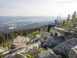
3.4 km On reaching the Steinernen Meer (large block pile from the last ice age), enjoy the magnificent panoramic view. You walk back to where the path divides and take the Seesteig uphill to the...
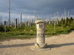
4.2 km Dreieckmark (meeting point of the states of Austria-Bavaria-Czech Republic).
You continue in an easterly direction parallel to the Path of Deceleration, where after another 1-hour walk you arrive at the....
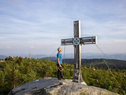
6.0 km at Plöckenstein (highest elevation in the Mühlviertel at 1379 m). A detour to the Stifterdenkmal (20 minutes one way) and to Plöckensteinersee (55 minutes one way) on the Czech side is worthwhile. The view of the lake from the Stifter obelisk is particularly impressive.
However, bear in mind the difference in altitude to Plöckensteinersee, which is around 300 metres over about 2 km, and allow around 2 hours for the outward and return journey to Plöckenteinersee.
At Plöckenstein, continue the hike eastwards along the Grenzsteig trail. After about 10-15 minutes, branch off to the right from the Grenzsteig and head towards Schwarzenberg Ort, together with the Plöckensteinerseeweg trail no. 21, which you leave again at the Zwiesel shelter hut.
Here you continue to the right towards Schwarzenberg and after about ½ hour you come to the Bavarian-Austrian border stream, where you were already at the start of the hike. Follow the same route via the Teufelsschüsseln (Devil's Bowls) back downhill to the...
12 km starting point of the hike.
Request our hiking map for EUR 3.00 here!
With the free app outdooractive you can hike the trail by navigation.
0 km You start the hike in Oberschwarzenberg at Gasthof Dreiländereck and follow the signs (yellow aluminium signs indicating the destinations) Steinernes Meer, Dreiländereck, Plöckenstein and Weg der Entschleunigung.
1.8 km Don't overlook the turn-off to the right towards Teufelsschüsseln shortly afterwards. An ascending forest path follows. Once you reach the Teufelsschüsseln, you can enjoy a beautiful view after climbing up the steps.
Soon afterwards you will reach a narrow forest road, cross it and shortly afterwards reach a wider forest road. Follow this uphill until you reach a sharp bend to the right.
Leave the forest road here and turn left. A short time later you reach the Grenzbach stream. Here you also meet the Nordwaldkammweg. Cross the Grenzbach and follow the signs to the Steinernen Meer
3.4 km On reaching the Steinernen Meer (large block pile from the last ice age), enjoy the magnificent panoramic view. You walk back to where the path divides and take the Seesteig uphill to the...
4.2 km Dreieckmark (meeting point of the states of Austria-Bavaria-Czech Republic).
You continue in an easterly direction parallel to the Path of Deceleration, where after another 1-hour walk you arrive at the....
6.0 km at Plöckenstein (highest elevation in the Mühlviertel at 1379 m). A detour to the Stifterdenkmal (20 minutes one way) and to Plöckensteinersee (55 minutes one way) on the Czech side is worthwhile. The view of the lake from the Stifter obelisk is particularly impressive.
However, bear in mind the difference in altitude to Plöckensteinersee, which is around 300 metres over about 2 km, and allow around 2 hours for the outward and return journey to Plöckenteinersee.
At Plöckenstein, continue the hike eastwards along the Grenzsteig trail. After about 10-15 minutes, branch off to the right from the Grenzsteig and head towards Schwarzenberg Ort, together with the Plöckensteinerseeweg trail no. 21, which you leave again at the Zwiesel shelter hut.
Here you continue to the right towards Schwarzenberg and after about ½ hour you come to the Bavarian-Austrian border stream, where you were already at the start of the hike. Follow the same route via the Teufelsschüsseln (Devil's Bowls) back downhill to the...
12 km starting point of the hike.
Request our hiking map for EUR 3.00 here!
With the free app outdooractive you can hike the trail by navigation.
Starting point: Dreiländereck Inn, Oberschwarzenberg.
Destination: Dreiländereck Inn, Oberschwarzenberg.
further information:
- Flatly
- Possible accommodation
- Board possible
Most economical season
- Spring
- Summer
- Autumn
Please get in touch for more information.
Hauptstraße 4
4164 Schwarzenberg am Böhmerwald
Phone +43 5 7890 - 100
Fax machine +43 5 7890 - 115
E-Mail info@boehmerwald.at
Web www.boehmerwald.at
https://www.boehmerwald.at
You can also visit us on
Visit us on Facebook Visit us on Instagram Visit our videochannel on YouTube")
")
")
")
")
Interactive elevation profile
Create PDF
Tour-Details
Path number: Keine
Starting place: 4164 Schwarzenberg am Böhmerwald
Destination: 4164 Schwarzenberg am Böhmerwald
duration: 3h 51m
length: 11,1 km
Altitude difference (uphill): 530m
Altitude difference (downhill): 529m
Lowest point: 870m
Highest point: 1.369m
difficulty: difficult
condition: difficult
panoramic view: Dreamtour
Paths covering:
Asphalt, Hiking trail
powered by TOURDATA
