

Way of St. James Stage 5 Rohrbach-Berg - Pfarrkirchen


- culturally interesting
- Multi-day tour
- Possible accommodation
Interactive elevation profile
Create PDF
Tour-Details
Starting place: 4150 Rohrbach-Berg
Destination: 4141 Pfarrkirchen im Mühlkreis
duration: 7h 9m
length: 24,5 km
Altitude difference (uphill): 800m
Altitude difference (downhill): 590m
Lowest point: 490m
Highest point: 810m
difficulty: medium
condition: medium
panoramic view: Great panorama
Paths covering:
Asphalt, Gravel, Hiking trail
powered by TOURDATA
Section of the St. James's Path from Rohrbach-Berg to Pfarrkirchen.
Turn right across the Rohrbach-Berg town square, past the Holy Trinity Column, left into
Hanriederstraße, turn right into Grabenstraße at the next crossroads. Follow this
to the junction of the Götzendorfer Steig, turn left, go through the subway and
across the meadow to the beginning of the forest. Continue to the junction with the Sinnenreich path.
From here, continue straight ahead. Shortly afterwards, leave the wide path to the right on a narrow path down to the meadow, cross the Fischbach stream and turn right onto a
meadow path uphill towards the edge of the forest opposite. Follow the path briefly uphill and then
turn off the edge of the forest and continue left along the field path. Shortly afterwards, the path joins a tarmac
road, follow it uphill to the right. At the top, there is a lovely rest area next to the cross with a marvellous view of Rohrbach-Berg. Keep left at the road and continue in the direction of Götzendorf. A detour to Getzendorf Castle is worthwhile. Then return to the junction to Rumerstorf and follow the signposts to Brezerhaus. After Rumerstorf, take a meadow path via Koblmühle to Rutzersdorf (Brezerhaus). (At the Koblmühle you can turn left immediately after the bridge. The path leads to Auerbach.)
From the Brezerhaus in Rutzersdorf on the Brezer-Jausen-Weg on a very beautiful track, along
Rainen, partly through forest to Auerbach, then continue on a beautiful track to
Mairhof, then in the forest along the Kleine Mühl to the Sprinzelmühle, from there uphill on
a beautiful meadow path towards the village of Meising (beautiful view of the valley of the Kleine
Mühl and Sprinzenstein Castle), further uphill to Obernberg, through the forest down to Stampf, then steeply uphill to the centre of Sarleinsbach.
Stamping point for the Way of St. James stamp: Sarleinsbach vicarage
Continue on the Danube-Ameisberg circular route to the roundabout, through the village of Altendorf,
then descending meadow path to Leitenbach, after the Theresia-Kiesl path branches off to the left
on an asphalt road to the village of Eilmannsberg, after an 800 m long driveway or forest path,
then turn left onto the asphalt road to Eilmannsberg. forest path,
cross the Wullnerbrücke bridge and continue to the village of Wulln. From the village of Wulln in
the direction of Hanrieder Landesstraße, turn left halfway onto the meadow path - through the forest to the Maria Bründl pilgrimage church - now follow the Way of the Cross along the edge of the forest and enjoy the beautiful view of the village of Putzleinsdorf. Signposts for all hiking trails around Putzleinsdorf can be found at the municipal office.
Stamping point for Way of St James stamps: Ranetbauer Inn-Cafe, Markt 8
The Way of St James or pilgrimage trail goes through the market town of Putzleinsdorf. pilgrimage route goes through the market town of Putzleinsdorf past the pillory and
market fountain and turns left at the end of the village - follow the tarmac path and on the
hill turn right for approx. 2 km to the village of Männersdorf - keep left there and follow the path to the fork
Ebrasdorf/Pfarrkirchen - continue right to the "Hummelhof". Continue uphill through the
forest to the village of Spielleiten - continue straight ahead on the tarmac road - cross the
Frauenwald Landesstraße and continue uphill for about 1 km through the forest to the Panorama-
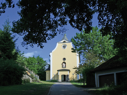
Cafe in Pfarrkirchen.
Stamping point for Way of St James stamp: Pension Panoramablick, Bauer Gerhard, Pfarrkirchen 40
Further stages of this Way of St James route.
Request our hiking map for EUR 3.00!
With the free app outdooractive you can hike the route by navigation.
Turn right across the Rohrbach-Berg town square, past the Holy Trinity Column, left into
Hanriederstraße, turn right into Grabenstraße at the next crossroads. Follow this
to the junction of the Götzendorfer Steig, turn left, go through the subway and
across the meadow to the beginning of the forest. Continue to the junction with the Sinnenreich path.
From here, continue straight ahead. Shortly afterwards, leave the wide path to the right on a narrow path down to the meadow, cross the Fischbach stream and turn right onto a
meadow path uphill towards the edge of the forest opposite. Follow the path briefly uphill and then
turn off the edge of the forest and continue left along the field path. Shortly afterwards, the path joins a tarmac
road, follow it uphill to the right. At the top, there is a lovely rest area next to the cross with a marvellous view of Rohrbach-Berg. Keep left at the road and continue in the direction of Götzendorf. A detour to Getzendorf Castle is worthwhile. Then return to the junction to Rumerstorf and follow the signposts to Brezerhaus. After Rumerstorf, take a meadow path via Koblmühle to Rutzersdorf (Brezerhaus). (At the Koblmühle you can turn left immediately after the bridge. The path leads to Auerbach.)
From the Brezerhaus in Rutzersdorf on the Brezer-Jausen-Weg on a very beautiful track, along
Rainen, partly through forest to Auerbach, then continue on a beautiful track to
Mairhof, then in the forest along the Kleine Mühl to the Sprinzelmühle, from there uphill on
a beautiful meadow path towards the village of Meising (beautiful view of the valley of the Kleine
Mühl and Sprinzenstein Castle), further uphill to Obernberg, through the forest down to Stampf, then steeply uphill to the centre of Sarleinsbach.
Stamping point for the Way of St. James stamp: Sarleinsbach vicarage
Continue on the Danube-Ameisberg circular route to the roundabout, through the village of Altendorf,
then descending meadow path to Leitenbach, after the Theresia-Kiesl path branches off to the left
on an asphalt road to the village of Eilmannsberg, after an 800 m long driveway or forest path,
then turn left onto the asphalt road to Eilmannsberg. forest path,
cross the Wullnerbrücke bridge and continue to the village of Wulln. From the village of Wulln in
the direction of Hanrieder Landesstraße, turn left halfway onto the meadow path - through the forest to the Maria Bründl pilgrimage church - now follow the Way of the Cross along the edge of the forest and enjoy the beautiful view of the village of Putzleinsdorf. Signposts for all hiking trails around Putzleinsdorf can be found at the municipal office.
Stamping point for Way of St James stamps: Ranetbauer Inn-Cafe, Markt 8
The Way of St James or pilgrimage trail goes through the market town of Putzleinsdorf. pilgrimage route goes through the market town of Putzleinsdorf past the pillory and
market fountain and turns left at the end of the village - follow the tarmac path and on the
hill turn right for approx. 2 km to the village of Männersdorf - keep left there and follow the path to the fork
Ebrasdorf/Pfarrkirchen - continue right to the "Hummelhof". Continue uphill through the
forest to the village of Spielleiten - continue straight ahead on the tarmac road - cross the
Frauenwald Landesstraße and continue uphill for about 1 km through the forest to the Panorama-
Cafe in Pfarrkirchen.
Stamping point for Way of St James stamp: Pension Panoramablick, Bauer Gerhard, Pfarrkirchen 40
Further stages of this Way of St James route.
Request our hiking map for EUR 3.00!
With the free app outdooractive you can hike the route by navigation.
Starting point: The starting point for this stage is Rohrbach-Berg.
Destination: The destination of this stage is Pfarrkirchen.
further information:
- Multi-day tour
- Possible accommodation
- Board possible
Details - hiking
- themed path
Most economical season
- Spring
- Summer
- Autumn
Please get in touch for more information.
Hauptstraße 2
4160 Aigen-Schlägl
Phone +43 5 7890 - 100
Fax machine +43 5 7890 - 115
E-Mail info@boehmerwald.at
Web www.boehmerwald.at/
https://www.boehmerwald.at/
You can also visit us on
Visit us on Facebook Visit us on Twitter Visit us on Instagram Visit our videochannel on YouTube")
")
Interactive elevation profile
Create PDF
Tour-Details
Starting place: 4150 Rohrbach-Berg
Destination: 4141 Pfarrkirchen im Mühlkreis
duration: 7h 9m
length: 24,5 km
Altitude difference (uphill): 800m
Altitude difference (downhill): 590m
Lowest point: 490m
Highest point: 810m
difficulty: medium
condition: medium
panoramic view: Great panorama
Paths covering:
Asphalt, Gravel, Hiking trail
powered by TOURDATA
