Rennradtour Dreisessel


- Flatly
- Possible accommodation
Interactive elevation profile
Create PDF
Tour-Details
Starting place: 4160 Aigen-Schlägl
Destination: 4160 Aigen-Schlägl
duration: 7h 0m
length: 135,5 km
Altitude difference (uphill): 2.278m
Altitude difference (downhill): 2.284m
Lowest point: 543m
Highest point: 1.243m
difficulty: difficult
condition: difficult
panoramic view: Great panorama
Paths covering:
Asphalt
powered by TOURDATA
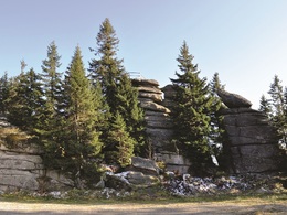
Challenging road bike tour to breathtaking summits such as the Dreisesselberg,
0 km This tour starts in Aigen-Schlägl. Leave the market square in a north-westerly direction. Turn right onto the Dreisesselberg country road, which will take you to
6 km Ulrichsberg. Continue through Salnau and Klaffer am Hochficht, from here you will reach
15 km Schwarzenberg. After approx. 1 km you will cross the border into Bavaria. The route takes you downhill to Klafferstraß. Turn right, after approx. 3 km, in Langbruck turn right again and follow the tour uphill to
25 km Neureichenau and on to Altreichenau. Continue along the village road to Frauen-
berg. After approx. 1.5 km, turn right. Uphill you reach the
41 km Dreisesselberg. Downhill again, turn right at the main road and continue your tour towards Haidmühle. Stay on the main road, through the villages of Bischofsreut and Schwarzenthal you will reach
63 km Philippsreut. Turn right onto the main road, follow it for approx. 1 km and turn left. Through several small villages you reach Annathalmühle, here you turn left to
76 km Annathal. On roads through the Bavarian Forest you reach Heldengut, turn
right onto the main road, follow it for approx. 1.5 km and turn left again. Through the villages of Sonndorf and Hinterschmiding you reach Kaining. Turn left onto the main road and reach
92 km Grainet. Shortly after the end of the village, leave the main road to the left and
through several small villages you will reach
102 km Jandelsbrunn. Turn left onto the main road and leave it after about 500 metres to the right. Pass through the villages of Gsenget and Langbruck to get back to
Klafferstraß. Continue straight ahead until you reach Breitenberg. At the end of the village, keep
right and you will reach the Kriegwald border crossing. The Bräueraustraße takes you to
123 km Julbach. Turn left and then immediately right again uphill. Along the scenic mountain road, you will pass through many small rural villages and return to your starting point
135 km Aigen-Schlägl.
You can navigate the route using the free outdooractive app.
Most economical season
- Spring
- Summer
- Autumn
Please get in touch for more information.
Hauptstraße 2
4160 Aigen-Schlägl
Phone +43 5 7890 - 100
Fax machine +43 5 7890 - 115
E-Mail info@boehmerwald.at
Web www.boehmerwald.at
Web www.almesberger.at
https://www.boehmerwald.at
https://www.almesberger.at
https://www.almesberger.at
You can also visit us on
Visit us on Facebook Visit us on Instagram Visit our videochannel on YouTube")
Interactive elevation profile
Create PDF
Tour-Details
Starting place: 4160 Aigen-Schlägl
Destination: 4160 Aigen-Schlägl
duration: 7h 0m
length: 135,5 km
Altitude difference (uphill): 2.278m
Altitude difference (downhill): 2.284m
Lowest point: 543m
Highest point: 1.243m
difficulty: difficult
condition: difficult
panoramic view: Great panorama
Paths covering:
Asphalt
powered by TOURDATA
